June 08, 2026
Mont-Blanc
Current Risk Summary
Risk is limited above 3400m, and low below.
Updated 4 months ago
Danger Rating
Level 2
Moderate risk
Elevation
<3400m
Low risk
>3400m
Moderate risk
Affected Aspects
Highlighted directions indicate noted slopes.
Avalanche Triggers
Skier Triggered Avalanches
Some wind slabs in the recent snow.
Natural Avalanches
Recent wet snow in the sun.
Tomorrow's Trend
June 09, 2026
Forecasted Risk
Level 2
Moderate risk
→ Stable (Level 2)
Forecast Details
Limited risk level
Some snow showers in the morning, lots of clouds. A little fresh snow above 3000m. No change in risk.
Snow Stability
LAST BULLETIN OF THE SEASON.
Typical Avalanche Situation
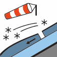
Snowdrift / Wind Slab (Wind-drifted Snow)
Wind transports snow and builds hard slabs on leeward slopes.
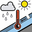
Wet Snow / Rain / Temperature Problem
Warming or rain weakens the snowpack, leading to wet-snow avalanches.
Avalanches Triggered by Skiers
- In shaded north-facing slopes above 3400m: rare, fragile slabs in the recent snow (10 to 30 cm), quite easily triggered by a skier. These slabs formed with west/southwest winds on Friday and Saturday. These slabs may also be present on sun-exposed slopes above 4000m, where the recent snow has not yet become wet. Slab size 1 (small), rarely 2 (medium).
- Monday evening above 3400m: some wind slabs formed during snowfall. Thin slabs (10 cm), easily triggered by a skier. These slabs were formed by strong west winds. Size 1, rarely 2.
- Above 2800m: wet recent snow can slide under skis in the afternoon. Size 1.
Spontaneous Avalanches
- Above 2800m, mainly in shaded north-facing slopes: some small wet recent snow avalanches as the sun warms the snow, especially near rocks/cliffs. Size 1.
Snow Quality
Snowpack and Coverage
- For the season, snow cover is below average. You can ski above 2300m on north-facing slopes.
Snow Quality Monday
- Below 2800m, corn snow on all aspects, light overnight refreeze above 2500m. The snow is warming up quickly in the morning.
- Between 2800m and 3400m: still some heavy recent snow on a hard base. Crusted snow at the start of the day, thawing during the morning.
- Above 3400m on north faces and 4000m on south faces: 10 to 15 cm of recent, fairly light snow, not yet very wet.
- Wind-affected snow near ridges and summits.
- Monday evening above 3400m: 5-10 cm of snow from showers. Often wind-affected snow.
Weather Forecast
Cloud veil thickening during the day. Locally stormy showers in the evening. Temperatures at 2000m: 8/16°C, at 4000m: -3/-1°C.


Snow Coverage
Date: Jun 07, 2026
Fresh Snow
Isotherm 0°C
Snow Depth by Elevation
Snow Limit
Bulletin Information
Data Source: This bulletin data is provided by Météo-France through their public API. Weather condition data is supplemented by Open-Meteo.
Disclaimer: This application displays avalanche bulletin information for informational purposes only. We do not assume any responsibility for the accuracy, completeness, or timeliness of the data provided. Users should always consult official sources and exercise their own judgment when making decisions related to avalanche safety. This information should not be used as the sole basis for any decisions regarding backcountry travel or avalanche risk assessment.