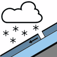
New snow
Numerous slabs easy to trigger in fresh windblown snow accumulations, with a few spontaneous releases possible.
Bulletin for Monday 23 November from Météo-France · issued Sunday 17:10, valid until Monday 19:00
ConsiderableLevel 3 · above 2,400 m
Danger
Considerable
Considerable above 2,400 m, Moderate below
Slopes
All aspects
Above 2,400 m
Problems
New snow Wind slab
Tomorrow, Tuesday
Considerable
No change
Danger stays at level 3 above 2,400 m and level 2 below. Wind slab is now listed alongside new snow, with slabs forming on all aspects above roughly 2,400 m, and natural releases are now attributed to wind-transported snow.
Written by AI from the official bulletin. Read it in full before you decide.
Above 2,400 m, danger level 3 (Considerable). Lower down, Moderate danger.
Numerous slabs that are easy to trigger in fresh windblown snow accumulations.
Under the effect of wind-transported snow
Tuesday 24 November
ConsiderableNo change
Considerable danger (level 3)
Considerable danger continues, with slabs still present at elevation.
Numerous slabs easy to trigger in fresh windblown snow accumulations, with a few spontaneous releases possible.
Slabs easy to trigger are forming on all aspects above roughly 2,400 m in wind-transported snow accumulations.
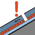
Slabs already in place at high elevation from earlier days; rare large avalanches possible on a persistent weak layer.
A few linear releases are possible in accumulations caused by wind-transported snow under the strong northwest wind currently blowing. Mostly possible above roughly 2,400 m. Size 2 avalanches, with rare size 3 possible at high elevation.
Above roughly 2,400 m, slabs that are easy to trigger are forming on all aspects in accumulations created by wind-transported snow. They add to slabs already in place at high elevation, formed in previous days. If they release, avalanches often reach medium size (size 2). They may occasionally produce thicker fractures at high elevation, and rare large avalanches (size 3) are expected, especially if the failure occurs on a persistent weak layer buried in the snowpack.
Below 2,400 m, a few unstable accumulations are also possible where recent snow is present, but they generally only produce small avalanches (size 1), and very rarely size 2.
Snow cover is close to normal at elevation, but very uneven due to episodes of strong wind.
28 cm at the Nivose du Parpaillon station at 2,545 m.
You can put skis on above 1900-2,000 m on grassy shaded north-facing slopes, but rocks are often poorly covered below 2,500 m or near high ridges.
Dry weather, generally sunny. Strong northwest wind still blowing during the day.
| Time | Sky | Wind at 3,000 m | Wind at 2,000 m | Freezing level | Snow line |
|---|---|---|---|---|---|
| 06:00 Mon |  Partly cloudy |
70 km/h NW from the NW | 35 km/h W from the W | 1,800 m | 1,400 m |
| 12:00 Mon | Mostly clear |
50 km/h NW from the NW | 15 km/h N from the N | 1,800 m | — |
| 18:00 Mon |  Clear |
40 km/h NW from the NW | 15 km/h N from the N | 2,000 m | — |
| 00:00 Tue | High cloud |
30 km/h NW from the NW | 15 km/h SE from the SE | 2,400 m | — |
50Wind of 50 km/h or more Arrows point where the wind blows to
Shaded column is today’s forecast


50Wind of 50 km/h or more Arrows point where the wind blows to
Translated from French by AvaRisk. Translations can contain errors, so check the official bulletin before you decide. AvaRisk shows this bulletin for information only; always consult official sources and use your own judgement in avalanche terrain.
Official bulletin at Météo-France